Bắc Ninh is located in the Red River Delta in the northern part of Vietnam. It is the smallest province of Vietnam and is situated to the east of Hanoi capital, and borders Bắc Giang Province, Hưng Yên Province, Hải Dương Province and Hanoi. The province covers an area of 822.71 square kilometres and as of 2019 it had a population of 1,368,840.
Bắc Ninh is situated about 30 kilometres from Hanoi and Nội Bài International Airport, and 100 km from Haiphong, Hạ Long, Cái Lân Port and Lạng Sơn border gate.
Bắc Ninh Province lies on the major traffic artery linking Vietnam and China – which is a strongly growing market and expected to be larger as the China – ASEAN free trade area is formed. It also lies on the Nanning – Lạng Sơn – Hanoi – Hai Phong and Nanning – Singapore economic corridors, the Hanoi capital city planning area and the busy Hanoi – Hai Phong – Quảng Ninh economic development triangle.
- Roadway: The province has over 3,906.8 km of road, 104.8 km of which are from 4 routes of national roads of No. 1 (old and new routes) (linking Hanoi – Bắc Ninh – Lạng Sơn), No. 18 (Nội Bài – Bắc Ninh – Hạ Long), No. 38 (Bắc Ninh – Hải Dương – Haiphong) and the Nội Bài-Hạ Long Expressway. 251 km are from routes of provincial roads, 404 km from district and urban areas, and some 3,147 km from commune and hamlet roads.
- Waterway: Three big rivers flowing through Bắc Ninh comprise the Cầu River which is 42 km long, Thái Bình River which is 17 km long, and Đuống River which is 42 km long. Also, there is Đáp Cầu Port, and two special ports of the Cầu River.
- Railway: A 20-km Hanoi-Lang Son Rail Route runs through Bắc Ninh and 4 railway stations of Từ Sơn, Lim, Bắc Ninh, and Thị Cầu. A 39-km Yên Viên-Phả Lại Rail Route is planned to be constructed in the districts of Tiên Du, Từ Sơn, Quế Võ and Bắc Ninh City.
- Power supply: Power is stably supplied for production and domestic consumption, comprising 120 km of 110kV national grid, 249.3 km of 35-kV electric lines and 3,700 km of 0.4kV electric lines. All districts and cities have national grid and all households use electricity.
Bắc Ninh is subdivided into 8 district-level sub-divisions: 6 districts, 1 district-level town, 1 provincial city. They are further subdivided into 6 commune-level towns (or townlets), 97 communes, and 23 wards.
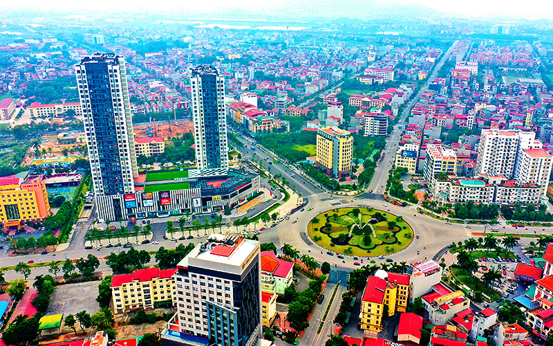
In terms of land area, Bắc Ninh is the smallest of all Vietnamese provinces (and in fact, is smaller than any of the five province-level municipalities). It is, however, home to a relatively large number of people for its size, having the highest population density of any province. On average, there are over 1,200 people for every square kilometre of land in Bắc Ninh.
Bắc Ninh has universities and colleges, vocational training skill secondary schools and centres providing investors with labour sources suitable for demand of high technical qualifications of enterprises.
- Bắc Ninh University of Physical Education and Sports (UPES1)
- Kinh Băc University
- Bắc Hà International University
- People’s Police University of Technology and Logistics – T36 (Đại học Kỹ thuật – Hậu cần Công an nhân dân)
- Academy of Policy and Development
- Dong A University of Technology
The province is rich in culture and is known nationally for Quan họ folk music. Quan họ was recognized as an Intangible Cultural Heritage by the UNESCO in 2009.

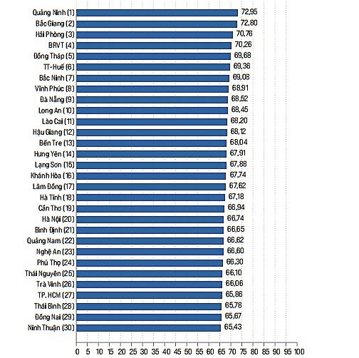
Bắc Ninh Province is known as a light point in industrial development, and has been lifting rapidly with long steps of industrialisation – modernisation. Bắc Ninh has 15 industrial parks with a total area of 7,681 ha, of which nine have operated effectively. The industrial parks have lured 272 foreign direct investment (FDI) projects totaling to over $3.7 billion, including those invested by Canon, Samsung, P&Tel, Sumitomo, Foxconn, ABB, Orion, PepsiCo and Nokia. They have attracted 254 domestic projects with a total registered capital of over $1 billion and a labour force of more than 83,000.
Bắc Ninh has as many as 120 handicraft-producing villages, 62 of which are involved in producing traditional products such as copper casting (Đại Bái-Gia Bình), iron and steel (Đa Hội-Từ Sơn), and wooden products (Đồng Kỵ-Kim Sơn). They have the upper hand and high potential to contribute to Bắc Ninh’s economic development.
Climate: Bac Ninh is located in a tropical monsoon climate with four distinct seasons, with cold winters and hot summers. The average relative humidity of Bac Ninh is about 81%. The average annual rainfall in Bac Ninh is about 1500mm but unevenly distributed throughout the year. The rainy season is mainly from May to October, accounting for 80% of the total annual rainfall. The dry season from November to the April of next year accounts for only 20% of the total rainfall in the year. Every year, there are two main monsoon seasons: Northeast monsoon and Southeast monsoon.
From a very poor agricultural province, with poor in mineral resources, after just over 20 years since the Provincial People’s Committee established the first industrial park, Bac Ninh has really made a spectacular breakthrough. Although it is still not an industrial center, it is believed that Bac Ninh will achieve this role in a short time.
Currently, the province is still constantly promoting effective implementation and focused investment. Also, it develops ancillary services such as banking, logistics, customs declaration, communication… to provide the best services to the production and business activities of enterprises in the industries parks.
Below is a list of 15 industrial parks in Bac Ninh that have been put into operation:
Bắc Ninh is located in the Red River Delta in the northern part of Vietnam. It is the smallest province of Vietnam and is situated to the east of Hanoi capital, and borders Bắc Giang Province, Hưng Yên Province, Hải Dương Province and Hanoi. The province covers an area of 822.71 square kilometres and as of 2019 it had a population of 1,368,840.
Bắc Ninh is situated about 30 kilometres from Hanoi and Nội Bài International Airport, and 100 km from Haiphong, Hạ Long, Cái Lân Port and Lạng Sơn border gate.
Bắc Ninh Province lies on the major traffic artery linking Vietnam and China – which is a strongly growing market and expected to be larger as the China – ASEAN free trade area is formed. It also lies on the Nanning – Lạng Sơn – Hanoi – Hai Phong and Nanning – Singapore economic corridors, the Hanoi capital city planning area and the busy Hanoi – Hai Phong – Quảng Ninh economic development triangle.
- Roadway: The province has over 3,906.8 km of road, 104.8 km of which are from 4 routes of national roads of No. 1 (old and new routes) (linking Hanoi – Bắc Ninh – Lạng Sơn), No. 18 (Nội Bài – Bắc Ninh – Hạ Long), No. 38 (Bắc Ninh – Hải Dương – Haiphong) and the Nội Bài-Hạ Long Expressway. 251 km are from routes of provincial roads, 404 km from district and urban areas, and some 3,147 km from commune and hamlet roads.
- Waterway: Three big rivers flowing through Bắc Ninh comprise the Cầu River which is 42 km long, Thái Bình River which is 17 km long, and Đuống River which is 42 km long. Also, there is Đáp Cầu Port, and two special ports of the Cầu River.
- Railway: A 20-km Hanoi-Lang Son Rail Route runs through Bắc Ninh and 4 railway stations of Từ Sơn, Lim, Bắc Ninh, and Thị Cầu. A 39-km Yên Viên-Phả Lại Rail Route is planned to be constructed in the districts of Tiên Du, Từ Sơn, Quế Võ and Bắc Ninh City.
- Power supply: Power is stably supplied for production and domestic consumption, comprising 120 km of 110kV national grid, 249.3 km of 35-kV electric lines and 3,700 km of 0.4kV electric lines. All districts and cities have national grid and all households use electricity.
Bắc Ninh is subdivided into 8 district-level sub-divisions: 6 districts, 1 district-level town, 1 provincial city. They are further subdivided into 6 commune-level towns (or townlets), 97 communes, and 23 wards.
In terms of land area, Bắc Ninh is the smallest of all Vietnamese provinces (and in fact, is smaller than any of the five province-level municipalities). It is, however, home to a relatively large number of people for its size, having the highest population density of any province. On average, there are over 1,200 people for every square kilometre of land in Bắc Ninh.
Bắc Ninh has universities and colleges, vocational training skill secondary schools and centres providing investors with labour sources suitable for demand of high technical qualifications of enterprises.
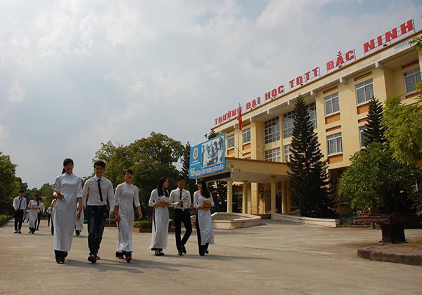
- Bắc Ninh University of Physical Education and Sports (UPES1)
- Kinh Băc University
- Bắc Hà International University
- People’s Police University of Technology and Logistics – T36 (Đại học Kỹ thuật – Hậu cần Công an nhân dân)
- Academy of Policy and Development
- Dong A University of Technology
The province is rich in culture and is known nationally for Quan họ folk music. Quan họ was recognized as an Intangible Cultural Heritage by the UNESCO in 2009.
Bắc Ninh Province is known as a light point in industrial development, and has been lifting rapidly with long steps of industrialisation – modernisation. Bắc Ninh has 15 industrial parks with a total area of 7,681 ha, of which nine have operated effectively. The industrial parks have lured 272 foreign direct investment (FDI) projects totaling to over $3.7 billion, including those invested by Canon, Samsung, P&Tel, Sumitomo, Foxconn, ABB, Orion, PepsiCo and Nokia. They have attracted 254 domestic projects with a total registered capital of over $1 billion and a labour force of more than 83,000.
Bắc Ninh has as many as 120 handicraft-producing villages, 62 of which are involved in producing traditional products such as copper casting (Đại Bái-Gia Bình), iron and steel (Đa Hội-Từ Sơn), and wooden products (Đồng Kỵ-Kim Sơn). They have the upper hand and high potential to contribute to Bắc Ninh’s economic development.
Climate: Bac Ninh is located in a tropical monsoon climate with four distinct seasons, with cold winters and hot summers. The average relative humidity of Bac Ninh is about 81%. The average annual rainfall in Bac Ninh is about 1500mm but unevenly distributed throughout the year. The rainy season is mainly from May to October, accounting for 80% of the total annual rainfall. The dry season from November to the April of next year accounts for only 20% of the total rainfall in the year. Every year, there are two main monsoon seasons: Northeast monsoon and Southeast monsoon.
From a very poor agricultural province, with poor in mineral resources, after just over 20 years since the Provincial People’s Committee established the first industrial park, Bac Ninh has really made a spectacular breakthrough. Although it is still not an industrial center, it is believed that Bac Ninh will achieve this role in a short time.
Currently, the province is still constantly promoting effective implementation and focused investment. Also, it develops ancillary services such as banking, logistics, customs declaration, communication… to provide the best services to the production and business activities of enterprises in the industries parks.
Below is a list of 15 industrial parks in Bac Ninh that have been put into operation: